


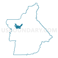
Voting District 30215, Butte County, California
About
Outline

Summary
| Unique Area Identifier | 529071 |
| Name | Voting District 30215 |
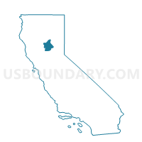
| County | Butte County |
| State | California |
| Area (square miles) | 21.23 |
| Land Area (square miles) | 21.18 |
| Water Area (square miles) | 0.04 |
| % of Land Area | 99.79 |
| % of Water Area | 0.21 |
| Latitude of the Internal Point | 39.77728680 |
| Longtitude of the Internal Point | -121.81256180 |
Maps

Graphs
Select a template below for downloading or customizing gragh for Voting District 30215, Butte County, California


Neighbors
Neighoring Voting District (by Name) Neighboring Voting District on the Map
- Voting District 20155, Butte County, CA
- Voting District 30205, Butte County, CA
- Voting District 30210, Butte County, CA
- Voting District 30220, Butte County, CA
- Voting District 30221, Butte County, CA
- Voting District 30225, Butte County, CA
- Voting District 30226, Butte County, CA
- Voting District 30227, Butte County, CA
- Voting District 30230, Butte County, CA
- Voting District 30235, Butte County, CA
- Voting District 30245, Butte County, CA
- Voting District 30250, Butte County, CA
- Voting District 30251, Butte County, CA
- Voting District 30252, Butte County, CA
- Voting District 30265, Butte County, CA
- Voting District 30275, Butte County, CA
- Voting District 30280, Butte County, CA
- Voting District 30295, Butte County, CA
- Voting District 40305, Butte County, CA
- Voting District 40330, Butte County, CA
- Voting District 40435, Butte County, CA
- Voting District 40440, Butte County, CA
Top 10 Neighboring County Subdivision (by Population) Neighboring County Subdivision on the Map
Top 10 Neighboring Place (by Population) Neighboring Place on the Map
Top 10 Neighboring Unified School District (by Population) Neighboring Unified School District on the Map
Top 10 Neighboring State Legislative District Lower Chamber (by Population) Neighboring State Legislative District Lower Chamber on the Map
Top 10 Neighboring State Legislative District Upper Chamber (by Population) Neighboring State Legislative District Upper Chamber on the Map
Top 10 Neighboring 111th Congressional District (by Population) Neighboring 111th Congressional District on the Map
Top 10 Neighboring Census Tract (by Population) Neighboring Census Tract on the Map
- Census Tract 4.02, Butte County, CA (7,030)
- Census Tract 9.03, Butte County, CA (6,117)
- Census Tract 9.04, Butte County, CA (6,071)
- Census Tract 14, Butte County, CA (5,797)
- Census Tract 1.04, Butte County, CA (5,636)
- Census Tract 8, Butte County, CA (5,295)
- Census Tract 16, Butte County, CA (5,266)
- Census Tract 10, Butte County, CA (4,801)
- Census Tract 7, Butte County, CA (4,694)
- Census Tract 3, Butte County, CA (4,410)